2021 has been a busy year with many improvements and new capabilities introduced in ArcGIS Online and related products. Whether you’re making maps to fight wildfires, mitigate COVID, plan cities, increase resilience, respond to severe weather events, or improve your business, ArcGIS Online continues to evolve to better support your needs and activities.
It’s easy to overlook some of the changes and improvements that have occurred over the course of the past year, especially when you’re busy or don’t have time to explore all of the new capabilities. As a refresher, here’s an overview of what’s been delivered with links to all the details.
The Top picks and Other highlights are subjective, so view the entire update blog article to make your own picks and discover new features that you may have missed.
Quick links
Use the links below to jump to a specific release.

April 2021
Top picks
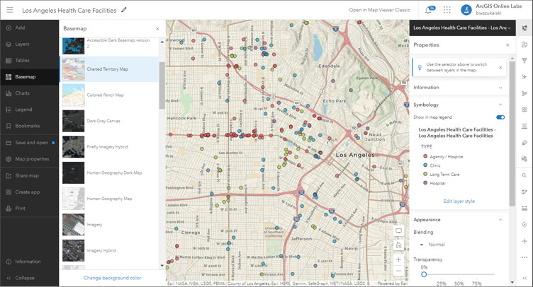
The new Map Viewer came out of beta, delivering a new map authoring experience with new features and capabilities. The previous viewer has been renamed Map Viewer Classic. Administrators can choose which to set as the default for their organization, individual members can specify their own preference. For more information, see Get started with Map Viewer.

ArcGIS Online organizations were provided the ability to more easily collaborate with other organizations by establishing a partnered collaboration. A partnered collaboration establishes trust between two or more organizations to share, contribute, and update content securely using groups. For an overview of collaborations, see Understand collaborations.
Other highlights
The new ArcGIS Dashboards came out of beta and became the default ArcGIS Dashboards experience. The new version added support for ArcGIS Arcade, new data sources, selection-based display, and improved performance.
ArcGIS Notebooks added scheduling to automate routine tasks, run large or lengthy processes during off hours, or deliver data updates. To learn how to use Notebooks, see Get started with notebooks.
Home page customization added color configuration via themes which define the text, background, headline, button, and link colors. Also added was WCAG 2.1 accessibility hints.
New ArcGIS Instant Apps were introduced, featuring the latest streamlined configuration experience that lets you build apps quickly and easily using express or full setup modes.
Scene Viewer introduces the ability to create elevation profile charts. Using these charts you can compare the heights for terrain and/or other 3D objects.
The ArcGIS Experience Builder table widget came out of beta and was fully released, supporting secure attribute editing.
All the details
What’s new in ArcGIS Online (April 2021)
All April 2021 release articles
June 2021
Top picks
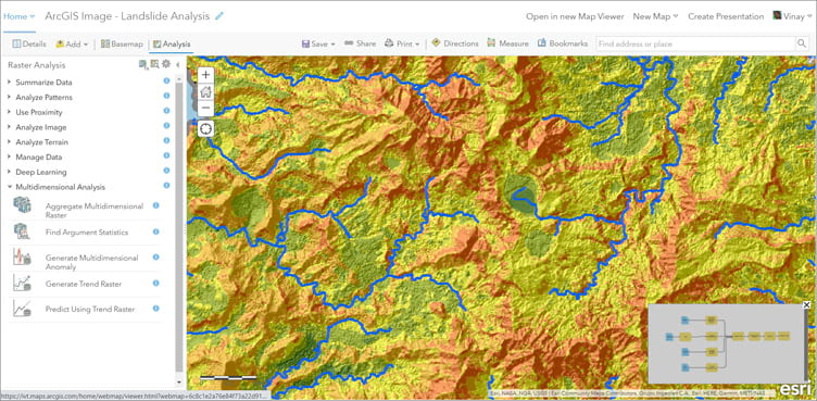
ArcGIS Image for ArcGIS Online is introduced, making it easier for organizations to access, manage, and use imagery data. You can host, analyze and stream your imagery and raster collections from ArcGIS Online or from your own cloud as a software as a service (SaaS) solution.

The experience for adding content to ArcGIS was streamlined with the addition of a New item button on the content page. The improved experience also includes support for dragging and dropping files such as CSV, PDFs, Microsoft Office documents, and images.
Other highlights
Scene Viewer editing was enhanced to enable editing of feature layers in scenes, including points, lines, and polygons. The addition enabled editing of attributes and the use of interactive handles to modify geometry, such as reshaping, rotating, and resizing.
Map Viewer was updated with the addition of layer refresh settings, adding tile layers and OGC feature layers from a URL, enhanced histograms, viewing floor-aware maps, and more.
ArcGIS Instant Apps released Portfolio and delivered improvements to Nearby. Countdown was introduced in beta.
ArcGIS Dashboards was redesigned and new configuration options were introduced. As a dashboard author, you can now choose a presentation mode for your selectors to better display them on your dashboard and include the ability to add icons to your selector and the option to reset a selector’s input.
Home page customization was enhanced with extended color and font support via preset or custom themes. For more information, see Create a great home page for your organization.
All the details
What’s new in ArcGIS Online (June 2021)
All June 2021 release articles
September 2021
Top picks
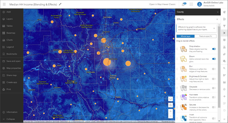
Effects were added to Map Viewer, letting you create expressive maps using creative visualizations that can be applied to basemaps and operational layers. Choose from effects like drop shadow, bloom, blur, grayscale, brightness and contrast, and more to achieve the desired results.
When using multiple effects, you can experiment with reordering them to change how effects are cumulatively applied. You can also combine effects with blend modes and different styling options to fine-tune the appearance of the map.

Charts came out of beta, letting you add bar charts, histograms, scatter plots, and line charts to your map to discover patterns, trends, and relationships.
ArcGIS Instant Apps Basic and Sidebar came out of beta and are now fully released. Slider and Chart Viewer are released in beta. Zone Lookup, Nearby, and Attachment Viewer were updated.
Other highlights
Scene Viewer was extended to support WGS 1984 layers in local scenes and WFS layers in any scene.
ArcGIS Dashboards adds the ability to configure your data-driven elements with a data download button. Dashboard viewers can download a CSV file of an element’s source data or summarized data which can be used for additional analysis and custom reports, or used in other applications.
Groups now includes the ability to configure a featured content gallery that lets you highlight important group content.
Administrators can now schedule administrative reports.
All the details
What’s new in ArcGIS Online (September 2021)
All September 2021 release articles
December 2021
Top picks
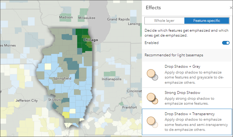
Map Viewer adds the ability to use filters to apply effects to specific features in a layer. For example, applying drop shadow + transparency to highlight features in a specific state. Map authors can decide whether to apply filters to the entire layer or only to specific features. When working with specific features, effects are now paired bringing together commonly used and visually effective options.

Pop-ups are enhanced with support for new Arcade elements and HTML editing. Over 160 new color ramps are now available when applying styles to layers.
ArcGIS Dashboards delivers a new layout panel and the ability to add table elements.
Other highlights
Feature layer tables were enhanced with the ability to select rows and zoom to the location of the extent of all selected features was added.
The ability to add GeoJSON layers from a URL to Map Viewer was added.
Scene Viewer adds the ability to create an app directly from within the viewer. Choose Instant Apps, Experience Builder, or StoryMaps to create apps and stories directly from your scenes.
ArcGIS Instant Apps fully release Slider, Chart Viewer, and Countdown. Exhibit is introduced in beta.
ArcGIS Experience Builder add an elevation profile widget and a suitability modeler widget.
A new experience for creating feature layers is introduced. When creating a blank layer, you can immediately add multiple layers of different types (point, line, polygon, or table). When creating feature layers from a template, you can preview the layers and fields before choosing the template.
The workflow for creating hosted feature layer views was improved, with the view definition now set as part of the view creation process. You can create a filtered view of your layer using attributes, by drawing a shape, or by using a shape from another layer.
All the details
What’s new in ArcGIS Online (December 2021)
All December 2021 release articles

More information
For more information, and to stay on top of announcements and forthcoming releases, see the following:
The year ahead
There are many new capabilities incremental improvements that will be introduced throughout 2022. You can contribute your ideas and help prioritize what’s delivered by providing feedback via ArcGIS Ideas.


Commenting is not enabled for this article.