ArcGIS Excalibur transforms the way analysts search, discover, and work with imagery by unifying traditionally separate geospatial and imagery-based views into a single integrated experience. An easy-to-use web-based experience, Excalibur has the power to improve daily decision-making across organizations.
The November 2021 release of ArcGIS Excalibur delivers a wide range of exciting new capabilities that enhances observation management workflows, including GeoEnriched Observation Layers, exporting imagery, and a new pixel-based tool to detect change between two images.
Highlights from the November 2021 release include: GeoEnriched Observation Layers, export and download image workflows, and automated pixel-based comparisons. Read more.
GeoEnriched Observation Layers
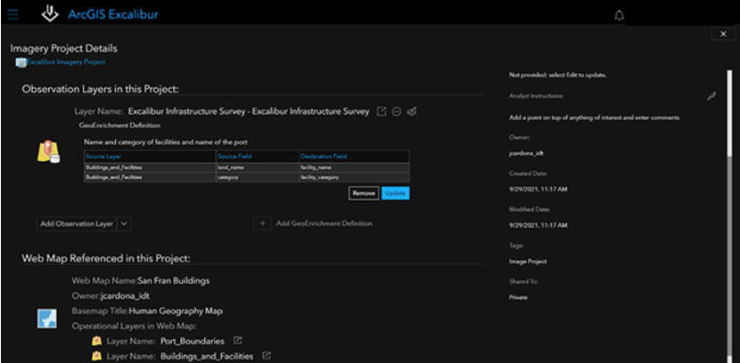
Imagery projects provide users with efficient ways to perform their work by organizing resources required to complete an image-based task in a single location. The upcoming release of Excalibur enhances imagery projects by adding GeoEnrichment definitions to observation layers in your project. When a GeoEnrichment definition is configured with your observation layer, it will automatically add information from a related context layer to the existing observation layer. For example, using an aircraft observation layer, a user collects the presence of an aircraft at a known airfield. The selected airfield values auto-populate the aircraft observation layer with updated information, saving the user time and preventing “copy and paste” errors.
Export and download image workflows
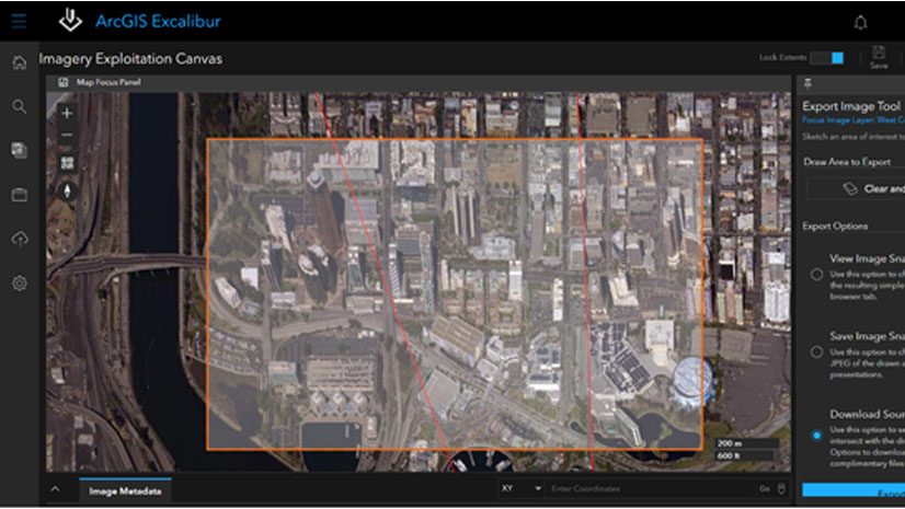
Excalibur serves many imagery functional roles within an organization, including search and discovery imagery analysis and exploitation and sharing results for decision-making. Using the Export Image tool, users will now have the option to save an image as an image snapshot or download the full resolution source image and its supported files from the map focus panel or image focus view. The image snapshot is recommended for briefings and presentations, while the source image is for utilizing in additional mapping applications as it contains image metadata, including resolution.
Automated pixel-based comparisons
For many analysts, manually comparing changes between two images is a daunting task. The new Detect Change tool uses multiple raster functions to conduct automated pixel-based comparisons between two images selected in the image metadata table. Users select the two images of interest, apply the Detect Change tool, and results immediately appear on screen. This tool can be run in an imagery project and results can be shared in an imagery report.
Stay in the Know
ArcGIS Excalibur continues to transform imagery workflows with constant improvements in response to customer input, building on the capabilities of ArcGIS. To learn more about Excalibur and add it to your organization’s ArcGIS Enterprise deployment, get in touch with an Esri representative at go.esri.com/excalibur, or visit the new Resources page to access on-demand, no-cost training; documentation; videos; articles; and more.


Article Discussion: