One more release to close 2021, and what a release! ArcGIS QuickCapture 1.12 now includes support for location tracking. Read on to learn more…
What is ArcGIS QuickCapture?
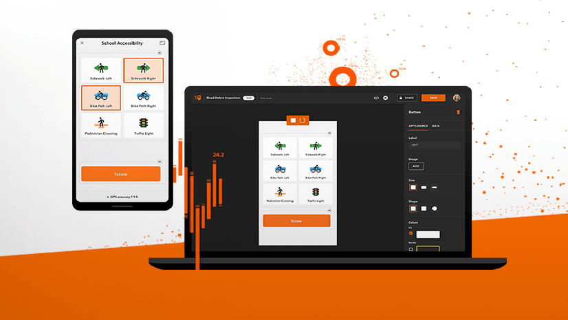
ArcGIS QuickCapture is Esri’s rapid data collection mobile app. Use QuickCapture to give field users the simplest and most efficient experience for documenting field observations.
QuickCapture is as simple to use as the camera app in your phone, but much more powerful. It helps you collect the location of observations in the field and automatically enrich them with multiple attributes. A single tap in your phone records the what, the where and the when. Once collected, you can share that information through ArcGIS.
Not familiar with the BIG button user experience of QuickCapture? Give it a try through the various sample configurations we share through this gallery. Photo inspections, quick asset damage reports, bioblitz and much more! Ready to get started? Follow this tutorial to create your first project from scratch.
Location tracking in ArcGIS QuickCapture
Location tracking is an ArcGIS Online and ArcGIS Enterprise capability. It provides the ability to record where users are and where they have been. You can now configure your ArcGIS QuickCapture projects to leverage location tracking. Why is this useful? Well, location tracking can help you better monitor field activities. As your field users collect data using QuickCapture, their last known location is sent into ArcGIS. Through a dashboard, you can use this information for situational awareness and to support operations. Thanks to location tracking, the QuickCapture mobile app will also keep a history of where field workers have been and when. This information can be critical to understand where work has been performed. Use this information to avoid duplication of efforts or as proof of work.
Enabling location tracking in your ArcGIS QuickCapture project
Right from within ArcGIS QuickCapture designer, you will see a new Location Tracking settings option. Use it to activate and manage location tracking within your project.
You can choose to configure location tracking as an optional or required feature:
- Required: Users will be tracked as long as they keep the QuickCapture project open. If you want your users to always be tracked, this is the best choice.
- Not required: End users will decide when they want to be tracked.
By default, the QuickCapture mobile app sends the last known location of the user to ArcGIS every minute, but you can change it to 15 minutes or 1 hour.
Location tracking in the QuickCapture mobile app
The way users interact with location tracking from the mobile app depends on how the author configures the project:
- If the QuickCapture project is not configured with location tracking, the end user will not see options to work with location tracking. Even if location tracking is enabled in the organization.
- When location tracking is enabled, a green bar at the bottom of the project will display the location tracking status.
Displaying location tracking information in the QuickCapture app
By default, location tracking information is not shown to users in the mobile app. However, if you need mobile users to see the last known location or tracks of their colleagues, you can change that. For situational awareness, field workers may need to know where other field crews are. To avoid duplication of work, you may want to share tracks from other members of the team.
First, author a web map. Ask the ArcGIS administrator to create a location tracking view* and add it to your web map. You can also add extra layers of information if you like. Click on the Configure project map button in QuickCapture designer. Change your QuickCapture project web map so it points to yours. Save the project, and you are done!
Note: Location tracking views are special. They need to be created by an administrator and users with access to view the data must be granted special privileges. More info here.

ArcGIS QuickCapture location tracking deployment guide
The Deploy a Location Tracking Solution with ArcGIS QuickCapture guide is a brief document with essential tasks and best practices. Through links to relevant help topics, it provides and end-to-end guide to configure location tracking in your organization. Read this document to learn:
- How to enable location tracking within your organization
- Location tracking licensing requirements
- Best practices to secure your location tracking information
- The essentials for configuring QuickCapture projects with location tracking capabilities
- Tips to design effective dashboards and maps
Other features included in this release
Location tracking is the big highlight of this release, but don’t miss other enhancements. Get all the details from the What’s new help topic as well as this short video.
Questions? Join the ArcGIS QuickCapture Esri Community
We are excited about you taking advantage of this new release. If you have any questions or simply want to share your work and thoughts, join our discussion forum in Esri Community.


Commenting is not enabled for this article.