ArcGIS StoryMaps helps you tell remarkable stories with custom maps that inform and inspire. A story can effect change, influence opinion, and create awareness—and maps are an integral part of storytelling. ArcGIS StoryMaps can give your narrative a stronger sense of place, illustrate spatial relationships, and add visual appeal and credibility to your ideas.
ArcGIS StoryMaps is updated regularly, and this month we’re announcing two big new features, explorer tours and theme builder, as well as several other helpful enhancements.
- Explorer map tour
- Theme builder + theme builder enhancements
- Playback options for videos
- Use a web map for an express map basemap
- Usability improvements
- And more…
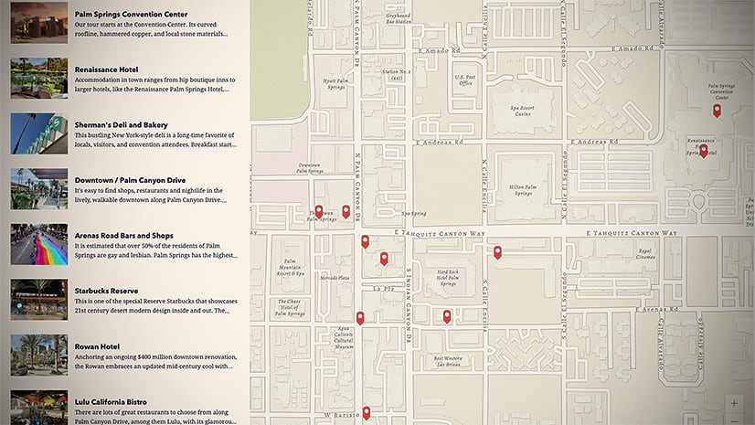
Explorer map tour (beta)
Long live Shortlist!
There’s a new immersive block in town: it’s a type of map tour called an explorer tour that is designed to help you present larger sets of places for your readers to, well, explore…any way they choose. The grid layout of the new explorer tour was inspired by the classic Story Map Shortlist template, and there’s also a list layout.
Building an explorer tour is similar to building a guided tour—just add a photo, title, and description for each place. Geotagged photos will be automatically placed on the map.
Stay tuned for future updates, because we’re working on more ways for you to create tours even faster.
For more examples and tips on how to use explorer tours in your stories, see Expand your storytelling horizons with explorer tour and our explorer tutorial.
Theme builder (beta)
Create your own theme
We know many of you in the storytelling community have been looking forward to having more flexibility to change the appearance of your stories. Now, in addition to the themes and other options available in the design panel, you can use theme builder to create your own themes.
A theme defines things like the colors, fonts, and block styles used in your story. All aspects of a theme are configured in the theme builder. After you create a theme, you publish it so it can be used in a story.
To apply a published theme to a story go to the story builder, open the design panel, and click Browse themes. You’ll see your published themes and can click one to select it.
If you want to browse all the themes you’ve created, you can get to the Themes page from your profile menu (shown below) or by clicking Manage in the Themes section of the design panel in the story builder.

Want to learn more about working with themes? Check out these additional resources:
Theme enhancements
Theme builder was released at the beginning of September, but we’ve already rolled out some big updates.
- You can now optionally specify a logo as part of a theme
- Several new fonts have been added based on requests from our storytelling community: Arial, Georgia Pro, Helvetica Neue, and Verdana Pro (dyslexia-friendly)
Note that “Pro” fonts include additional characters for expanded language support, but are otherwise the same as their non-pro versions.
What’s coming for themes?
We’re excited to make theme builder available, but keep in mind it’s still new and in beta. We know you’ll want more, and we’ve got a lot more planned!
Something to be aware of is themes are currently only available to their creators. That means you can (for now) only use themes you’ve created. But don’t worry, we know a big advantage of themes is sharing them, and we’re working on providing the ability to use themes created by others in the near future.
Some other things we’re looking at for the future include:
- Color picker
- Contrast checker (to let you know if your theme colors meet accessibility guidelines)
- More style, font, and spacing options
Please let us know what you think of theme builder so far and what you’d like to see by dropping us a note on GeoNet.
Playback options for videos
We’ve heard from members of the storytelling community who’ve asked for more control over how uploaded videos behave in stories. Now you can choose from several options for how uploaded videos behave and what controls are shown.

For linked videos, you can still use URL parameters supported by the video hosting platform (e.g, YouTube, Vimeo, etc.) to tailor the experience. These parameters must be specified using iframe code. See the Link vs. iframe code section of this blog for more details.
Additional basemap flexibility for express maps
Back in June, a gallery of beautiful, useful vector basemaps was added for use with express maps and guided tours. Then in July, we added the ability for you to pick a web map to use as the basemap for a guided tour.
Now, you can also pick a web map to define the basemap for an express map. You can pick from your own maps, your favorite maps, maps from colleagues in your organization, and also maps in the Living Atlas.
Usability improvements
Esri conducted more than a dozen usability studies as part of the recent virtual Esri User Conference. A goal of these studies is to improve your experience of using ArcGIS products.
The study focusing on ArcGIS StoryMaps identified several quick usability wins we could implement and uncovered two potential design issues for us to keep an eye on. We also confirmed that authors appreciate consistent patterns within ArcGIS StoryMaps and when those patterns are consistent with other ArcGIS products.
This month, we’re rolling out several of the quick wins identified in our study and we hope they make a positive impact for first-time authors and experienced storytellers. For example, all new stories now use the minimal cover style to make it easier to see how to continue building a story. Also, the slides panel is initially expanded after adding an immersive block, like a sidecar or guided tour, so it’s more apparent that you’re building a set of slides in these blocks. These and other small changes should make it easier for authors to discover and use the available builder tools.
Our team has more studies planned for the future, and we’ll continue to work to improve the usability of building and reading stories.
And more…
Other enhancements added this month include:
- The limit for the number of story navigation links has been increased to 30 (from 10)
- The swipe block is no longer in beta
- Co-authors can duplicate stories and collections. A co-author is a colleague who can also edit your story via membership in a shared update group. For more information on collaboration workflows, check out this blog post.
- Support for uploading SVG images to a story. This may come in handy if you’ve exported a model diagram from ArcGIS Pro, for example.
- ArcGIS StoryMaps product documentation in now available in six additional languages (French, German, Japanese, Russian, Spanish, and Simplified Chinese) and has a new release notes section so you can get more information about what’s been added, changed, and fixed in each update.
Banner photo by Robert Katzki on Unsplash


Article Discussion: