Part of the Esri Geospatial Cloud, ArcGIS Online enables you to connect people, locations, and data using interactive maps. Work with smart, data-driven styles and intuitive analysis tools that deliver location intelligence. Share your insights with the world or specific groups. With ArcGIS Online you can
- Quickly create maps by dropping in your spreadsheet and mashing it up with other location data included in ArcGIS Online. Apply Smart Mapping styles to make your data visually stunning.
- Instantly share your maps with anyone, anywhere. Work collaboratively with your colleagues to build maps and apps.
- Use intuitive analysis tools that help you learn more about your data. Add valuable context to your data by combining it with Esri’s demographic and lifestyle data.
Use ArcGIS Online as a standalone solution for your mapping and analytics needs. Or, because it’s an integral part of the ArcGIS system, you can use ArcGIS Online to extend the capabilities of ArcGIS Desktop, ArcGIS Enterprise, or build custom apps using ArcGIS Web APIs and SDKs. ArcGIS Online also provides access to the ArcGIS Living Atlas of the World, a vast collection of curated, authoritative, ready-to-use content from Esri and the global GIS user community.
March 2019 release
ArcGIS Online is updated regularly, and this latest release adds many useful new features and enhancements. This update introduces an improved account and administration experience, new and enhanced analysis tools, new configurable apps, and lots more. For additional details see the What’s new help topic or view all posts related to this release.
Configurable apps
Configurable apps use templates that you can configure easily, without any coding. They help you publish apps quickly for a variety of users and workflows. Configurable apps are the fastest and easiest way to go from a map to a shareable app. New for this release:
Interactive Legend is a new app that allows you to explore feature layers in the map by interacting with the legend. Viewers can explore the map visually, or select legend categories that are of the most interest to them. View the item page.

The Category Gallery app is no longer in beta. It enables you to build a gallery of maps, apps, and layers that can be filtered based on category. App authors can categorize group content into themes or topics of interest, and then offer them via the gallery search. View the item page for more information.
App builders
App builders let you easily create custom apps, no coding required, and you don’t have to be a designer, or even a map expert. App builders have been updated with the following enhancements:
Operations Dashboard for ArcGIS
Operations Dashboard for ArcGIS enables you to use maps alongside charts, gauges, and other visual elements to reflect the status and performance of people, services, assets, and events in real time. This Operations Dashboard update expands support for rich text when elements show No Data or No Value, and adds a new option for Category Selectors to deselect many items at once. In addition, three new languages are now supported: Ukrainian, Arabic, and Hebrew.
For more information, see What’s new in Operations Dashboard for ArcGIS.
Web AppBuilder for ArcGIS
Web AppBuilder for ArcGIS offers a way for you to easily create web apps that run on any device, using a gallery of ready-to-use-widgets. You can customize the look of your apps with configurable themes and can host your apps online or on your own server.
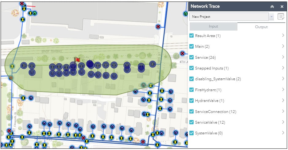
Web AppBuilder now includes support for accessibility in some widgets and themes for 2D apps. With incremental releases, more widgets and themes will support accessibility. In addition, the new Network Trace widget enables you to use a geoprocessing service to trace a geometric network and interact with the results.
When sharing a link or a URL to an app, you now can control which layers are visible with a new link option in the Share widget or with a new URL parameter Showlayers.
For more information, see What’s new in Web AppBuilder for ArcGIS.
AppStudio for ArcGIS
AppStudio for ArcGIS lets you turn your maps into beautiful, consumer-friendly mobile apps ready for Android, iOS, Windows, Mac OS X, and Linux. Your branded apps can be published to all popular app stores – no developer skills required. With AppStudio, organizations on the ArcGIS platform now have the ability to build cross-platform native apps easily.
AppStudio for ArcGIS 3.3 Beta is available via the Early Adopter Community. The Apple App Store has announced that all new apps and app updates submitted to the App Store need to be built with XCode 10 or later starting in March 2019, so in this beta the build environment of AppStudio has been upgraded to use XCode 10.1. This ensures that you can continue to upload your apps to the Apple App Store successfully.
AppStudio now also supports Enterprise Mobile Management (EMM) software to read and overwrite some default settings for iOS and Android devices. This allows you to manage and secure your apps and data across mobile devices.
For more information, see the AppStudio for ArcGIS 3.3 Beta release blog article.
Mapping and visualization
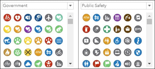
Symbol sets have been updated in Map Viewer. The Emergency Management symbol set has been renamed to Public Safety and includes new symbols. This symbol set also replaces the Safety & Health symbol set, which has been retired. The Local Government and State Government symbol sets have been combined into a single Government symbol set, which also includes new symbols.
You can now display georeferenced photos on a map by uploading a .zip file containing them. A hosted feature layer will be created showing the position of the photos, and links to view them. See Publish photos with locations for more information.
Spatial analytics
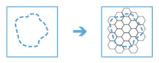
Generate Tessellations is a new tool that creates bins over a study area, determined by a specified extent, shape, and size. Tessellations are useful because they allow you to split geography into regular shapes that support many thematic mapping tasks, and enable you to see patterns much more easily.
The Elevation Analysis privilege is no longer required to run the Create Watersheds, Create Viewshed, or Trace Downstream tools. Therefore, these tools will not accrue credits when used.
The Browse Layers window has been updated to improve the experience of browsing to, and adding, analysis layers from within the tool pane. You can access the window by choosing Browse Layers from the drop-down menu of compatible tool parameters.
Sharing and collaboration
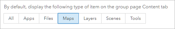
Group owners and managers can now specify an item type—All, Apps, Files, Maps, Layers, Scenes, or Tools—to filter and display content on the Overview and Content tabs. This is specified on the group page Settings tab. See Edit group properties and settings for more information.
A new location filter helps you find items in your organization that are located in a specific place or region, or at specified latitude, longitude coordinates. Item owners must set the item’s extent, or geographic boundaries, to take full advantage of this search filter.
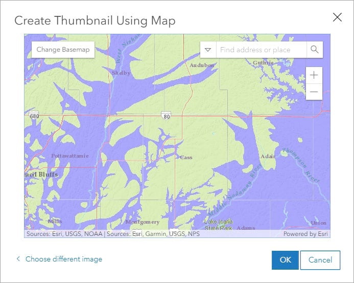
As an alternative to uploading an image, you can now create a custom thumbnail for your layer or map item by interacting with a map using Create Thumbnail Using Map. You can choose a different basemap, or change the zoom and location to get the desired results. See Thumbnail image for more information.
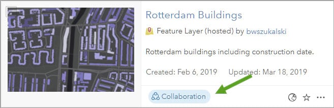
Organizations participating in a distributed collaboration can now share hosted feature layer views as copies between ArcGIS Online and ArcGIS Enterprise 10.7 portals. Insights for ArcGIS items, such as workbooks, pages, and models, can be shared from ArcGIS Enterprise 10.7 to ArcGIS Online. When an organization receives collaborated content, a badge is displayed on the item page to indicate that the item was received from another portal.
ArcGIS Online now returns relevant search results based on partial keyword matches to the item title.
When viewing content, you can now choose to display more items (20, 60, or 100) per page, making it more efficient to manage a large number of items. For example, you can delete or categorize many items in bulk.
ArcGIS Companion
ArcGIS Companion makes it easy to access your organization from your mobile device. In addition to the mobile browser option (just use your URL), you can now access your organization using this companion mobile app for iOS and Android. Access your organization anytime, anywhere, to explore content, view groups, edit your profile, and more.
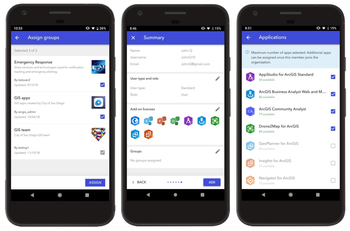
ArcGIS Companion has added more features and improvements since the previous ArcGIS Online update. Highlights include sharing a group via social media or with a URL, enhancements to the Discover page, and more options for managing members. The workflow for adding a member or inviting them to join the organization now includes steps to assign add-on licenses and add the member to groups. If your organization has set up enterprise logins, administrators can invite a member to join using their enterprise login. The Organization page has a new option for administrators to add a member to multiple groups at once.
For more information, see What’s new in ArcGIS Companion 2.2 (March 2019).
Living Atlas
ArcGIS Living Atlas of the World is the foremost collection of geographic information from around the globe. It includes curated maps, apps, and data layers from Esri and the global GIS user community that support your work. Visit the ArcGIS Living Atlas of the World website where you can browse content, view the blog, and learn how you can contribute. Here’s what’s new.
The OpenStreetMap vector basemap maintained and hosted by Esri, is no longer in beta. The OpenStreetMap basemap can be accessed as one of the standard basemaps in the basemap gallery for organizations that have enabled vector basemaps. Small areas can be exported for offline use. See What’s New with OpenStreetMap Basemap (March 2019) for more information.
Esri vector basemaps are now available in Czech, Finnish, Hebrew, and Swedish.
Try the new Community Maps Editor app (Beta) to add detail into your area of interest and enhance Esri’s basemaps. Get started today creating building footprints, athletic fields, walking paths, trees, and more. For more information see Introducing Community Maps Editor.
Demographic maps for the Netherlands, Switzerland, New Zealand, and several other countries in the Middle East and Latin America have been updated using the latest data from our providers. For more information, see the What’s new in Esri Demographics help topic and the What’s New in Esri Demographics (March 2019) blog article.
For all the latest information, see the Living Atlas blog.
Learn ArcGIS
Learn ArcGIS is a website containing timely and engaging guided lessons that are based on real-world problems, covering the entire ArcGIS platform. Whether you are new to GIS, or a seasoned analyst, Learn ArcGIS has resources to help you build your GIS skills. Most lessons require membership in an ArcGIS organization. And, if you don’t have ArcGIS yet, you can try it for 60 days by joining our ArcGIS Learn organization or sign up for a free ArcGIS trial to create your own organization.
Learn ArcGIS has recently published new resources, including a webinar on climate change mapping that shows you how you can use ArcGIS Pro to analyze climate data. Demonstrations shown at the Developer Summit 2019 plenary are being published in the Learn by Doing blog series. The first is Calculate Drone Corridors for Package Delivery which uses raster functions and the ArcGIS API for Python.
In addition, several new lessons, from deep learning, to search and rescue, to interest rate mapping have been published. You can find all of these and more in the Lesson Gallery.
Apps for the Office
ArcGIS apps for the office enable operations managers and analysts to visualize data in a geographic context to gain location-based insights and make decisions that save money and time. Some apps for the office have been updated. The following are highlights:
ArcGIS Maps for Office
ArcGIS Maps for Office puts Microsoft Excel data in context of location. You will see patterns and relationships to better understand a situation and make smarter decisions. Then, use Microsoft PowerPoint to share the results.
ArcGIS Maps for Office 5.0 is a major update that offers a completely redesigned user interface, improved workflows, and several new features. Add labels to map layers, view demographics related to features on the map, easily style and configure map layers, and many more enhancements.
For more information, see What’s new in ArcGIS Maps for Office.
ArcGIS Business Analyst Web
ArcGIS Business Analyst Web is a web-based solution that applies GIS technology to extensive demographic, consumer spending, and business data to deliver on-demand analysis, presentation-ready reports and maps. Select from a wide variety of existing reports, or create custom reports to meet your marketing needs.
The latest release brings a new set of starter infographic templates, improved dot density maps, the ability to use crime data and web layers in reports, new map marker symbols, top consumer segments for Canada, and much more.
For more information, see the What’s new in Business Analyst.
ArcGIS Earth
Explore any part of the world with ArcGIS Earth. Work with a variety of 3D and 2D map data formats, including KML. Display data, sketch placemarks, measure distances and areas, and add annotations.
In the ArcGIS Earth 1.9 release, new capabilities are added for KML and KMZ layers, including setting the refresh rate settings for the KML network link and displaying hyperlinks and snippets in the table of contents. This update also supports 3D navigation devices and adds the MrSID format for raster layers. In addition, numerous enhancements were made to improve the usability of the pop-up window, log-in process with PKI authentication, adding data, and rendering experiences, among others. ArcGIS Earth 1.9 is now available in Japanese, Polish, and Russian.
For more information, see What’s new in ArcGIS Earth.
Apps for the field
ArcGIS apps for the field help you use the power of location to improve coordination and achieve operational efficiencies in field workforce activities. Apps for the field have been updated with several enhancements. The following are highlights:
Collector for ArcGIS
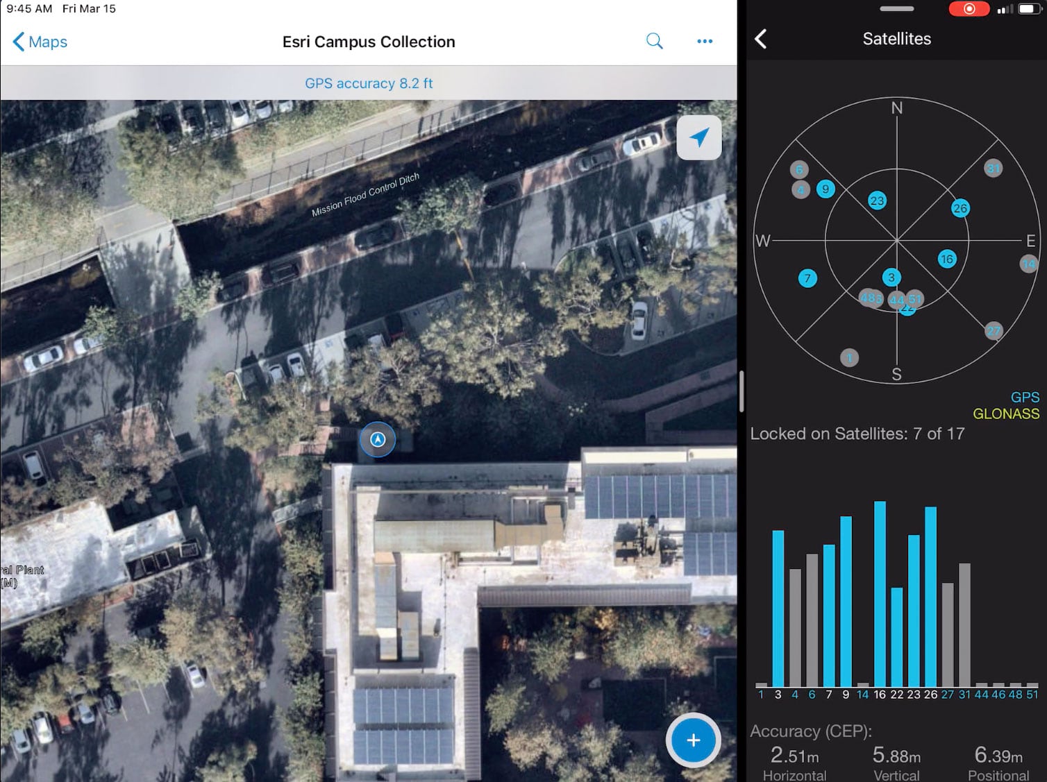
Collector for ArcGIS enables the use of your smartphone or tablet to collect and update information in the field, whether connected or disconnected.
Collector for ArcGIS can now be used alongside another app in Split View mode. Below, Collector is shown on the left with Bad Elf GPS on the right with its satellite constellation view.
Collector also now supports taking maps with the World Topographic basemap offline in on-demand map areas. A single-page field guide for mobile workers is also available.
For more information, see What’s new in Collector for ArcGIS.
Explorer for ArcGIS
Take your maps with you everywhere you go with Explorer for ArcGIS, a mobile app for iOS and Android. Take your GIS with you in the field, work offline, and add shapes and notations directly to your map.
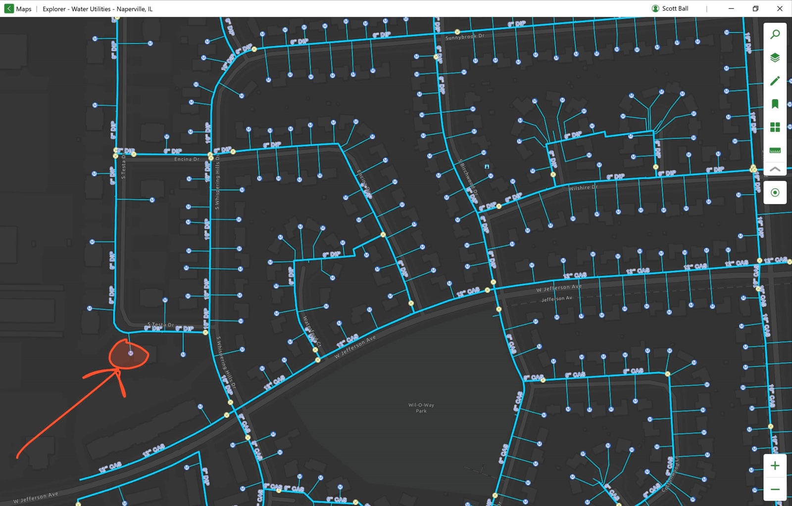
Explorer for ArcGIS is coming to Windows 10 (screenshot above). Now in beta, Explorer for Windows allows you to access your maps from your Windows 10 device, online or offline. Search for and view your data (including attachments and related data), mark up the map, and get directed to your hard-to-see assets with the compass. Get Explorer for Windows.
Survey 123
Survey123 for ArcGIS is a simple and intuitive form-centric data gathering solution that makes creating, sharing, and analyzing surveys possible in just three easy steps.
Survey123 for ArcGIS has had two incremental releases since the previous ArcGIS Online update. External GNSS receivers are now supported in the field app. The field app also includes a new point-to-point appearance type to enhance the Spike laser measurement solution, as well as a new symbol appearance type for geopoint questions to support custom markers. Other field app enhancements include higher zoom levels in tile packages and zooming in farther than a tile package’s maximum range.
In the Survey123 website, the Data page provides the ability to edit responses to surveys, and the Analyze page displays original responses for text questions. The web designer has improved the way questions and choices are named, and adds support for authoring a multiple-page survey, a new date/time question, and creating and importing custom themes in the web designer.
For more information, see What’s new in Survey123 for ArcGIS.
ArcGIS Hub
With sites, events, configurable apps, and other solutions, ArcGIS Hub enables your team to create and share initiatives that align collaborators across organizations and communities with the information and content they need to manage projects and drive desired outcomes.
ArcGIS Hub started off the new year with several feature enhancements including HTTPS support for sites with custom domains, faster ways to edit text and share content, more ways to explore data with a new search experience, and new navigation within the Site Editor.
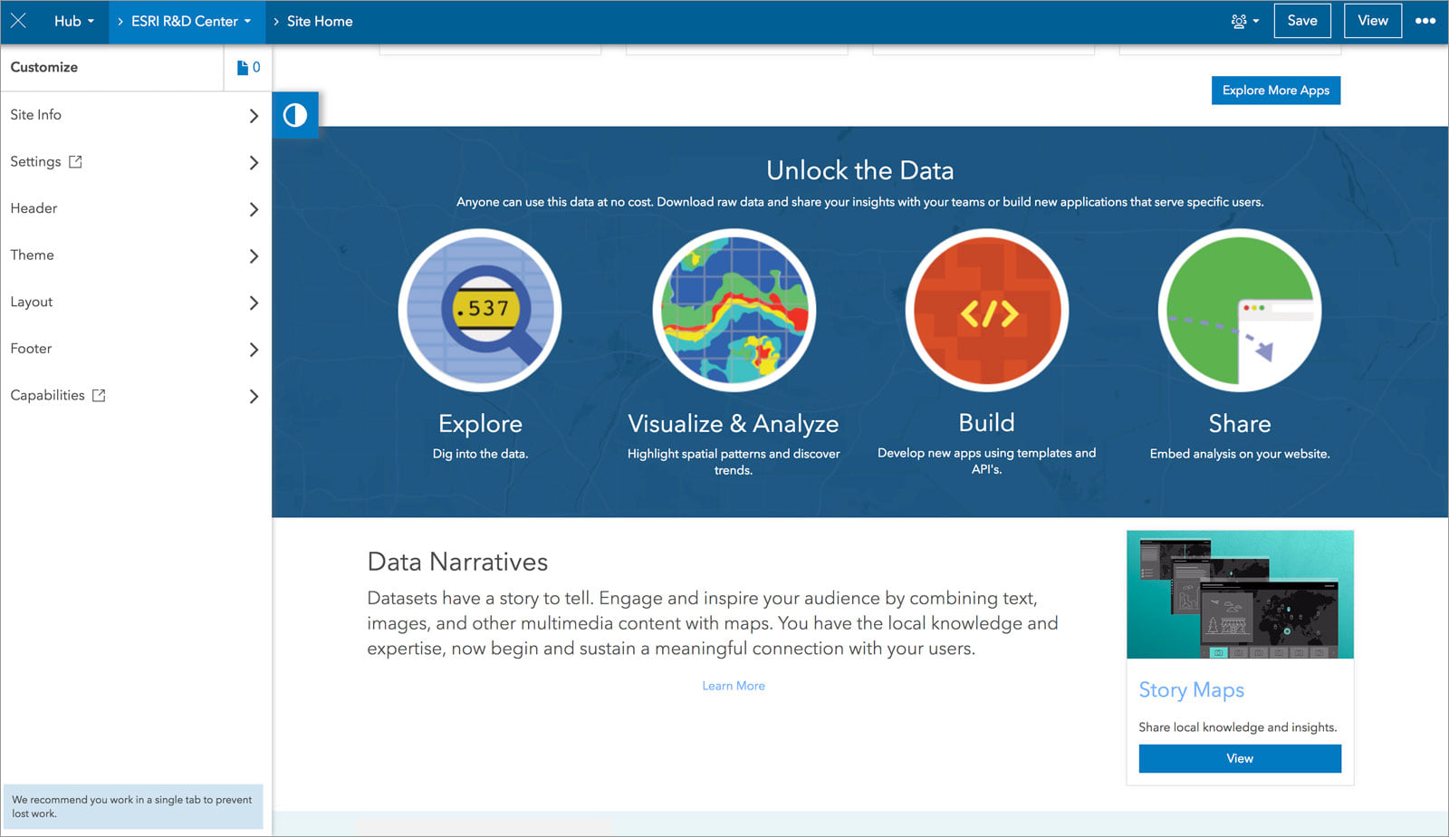
The new initiative template publisher also enables you to produce unlimited copies of your favorite initiatives so that you can streamline internal processes and projects or assist other organizations by sharing your successful workflows publicly.
For more information, see What’s New in ArcGIS Hub (March 2019) or check out the changelog to stay up to date on our releases.
Insights for ArcGIS
Insights for ArcGIS is web-based data analytics made for advanced location intelligence. Answer questions you didn’t know to ask, analyze data completely, and tell powerful data stories. Connect to your data directly, then use maps, charts and tables to perform basic to complex analyses that scale based on skill level and business need.
The March 2019 update of Insights for ArcGIS includes a redesigned and enhanced home page and support for distributed collaborations. ArcGIS Online also has a new Insights Analyst user type that can be used for members of your organization who only require access to Insights.
For more information, see What’s new in Insights.
Accounts and administration
ArcGIS Online now has more rigorous password requirements for new and updated accounts. A new password strength meter helps users and organization administrators create secure passwords.
If your organization has set up enterprise logins, you can now add members automatically using their enterprise ID. When adding members, the more rigorous password requirements also apply to temporary passwords.
The sign-in experience in ArcGIS Online has been updated and streamlined, making it easier to sign in.
Ukrainian language and Ukraine region are now supported in the website.
You can now assign add-on licenses to members during the invitation process. When the member accepts the invitation to join the organization, they’ll have immediate access to the apps and data you assigned.
Data management
A new job status is available when you rebuild a scene layer’s cache. Depending on the complexity and size of your data, rebuilding the cache can take a long time. The job status helps you monitor progress and, if the process fails, it provides a link to log files to help you troubleshoot the problem.
When you create a tile package in ArcGIS Pro 2.3 and later, you can specify a new file format—.tpkx. The .tpkx file format is an open specification tile package format that uses a simplified file structure, which allows developers to read and write files to the format. You can upload this new tile package format to ArcGIS Online and publish a tile layer.
To help the people who use your hosted feature layers determine how to use, style, and edit the data, you can add descriptions and define the types of values that should be stored in each field. Map Viewer uses what you set as the field value type to determine what styles are best to represent the data.
A new Arcade Attachments() function can be used during field calculations to calculate values based on attachments and their properties.
For more information
For more information and additional details, see the What’s new help topic or view all posts related to this release.


Commenting is not enabled for this article.